| Synoptic Settings |
|---|
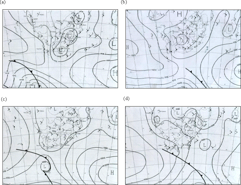
| On December 13 a weak cold front was present south of the continent with a heat low over the interior. A well-developed anticyclone was present in the South West Indian Ocean with associated easterly advection of moist air above the Agulhas Current along the southeast coast.On December 14, the inland heat low deepened from 1010 hPa to 1008 hPa as it shifted eastward. Interaction between this heat low, the midlevel trough that tracked over the region on December 14-15 with associated cold air advection aloft and the low level inflow of warm moist air from the Agulhas Current produced very favourable conditions for intense storm development. On December 15 the storm deepened and shifted slightly eastward (Figure 5c). Heavy rainfall occurred mainly over the Agulhas Current and coastal region releasing large amounts of latent heat. On December 16 (Figure 5d), the next anticyclone ridged in from the South Atlantic with associated advection of cooler, drier air into the region as the midlevel trough tracked further east. As a result, the surface low over the eastern Cape was displaced well out into the South West Indian Ocean and rainfall over land ceased. |
 |
|


[Abstract| Introduction| Agulhas Current | TRMM SST| Cloud Lines | Questions|
 Synoptic settings.|
Rainfall|
Visible Meteosat|
Infrared Meteosat|
The Movies|
TRMM Orbits|
TRMM Precipitation|
TRMM zoom|
TRMM vertical section|
Humidity flux 1|
Humidity flux 2|
Humidity flux vertical sections|
Conclusion|
References
Thanks]
Synoptic settings.|
Rainfall|
Visible Meteosat|
Infrared Meteosat|
The Movies|
TRMM Orbits|
TRMM Precipitation|
TRMM zoom|
TRMM vertical section|
Humidity flux 1|
Humidity flux 2|
Humidity flux vertical sections|
Conclusion|
References
Thanks]
Email: rouault@physci.uct.ac.za
Forum