| Agulhas Current |
|---|
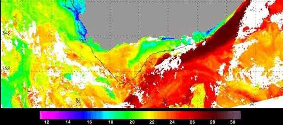
| The major oceanographic feature of the South West Indian Ocean is the warm Agulhas Current which flows along the east and south coasts of South Africa and is the most intense western boundary current in the Southern Hemisphere. Marked sea surface temperature (SST) gradients exist between the Agulhas waters and the ambient ocean (Figure 1) and with the cool Benguela Current upwelling system on the west coast of South Africa. Even though the core width of the Agulhas Current is relatively narrow, approximately 100 km, a large portion of the Southwest Indian Ocean is influenced by what may be termed as the greater Agulhas Current and the resulting recirculation region southeast of the subcontinent. Further observational evidence for the significant latent heat fluxes in the area was obtained during the Agulhas Current Air Sea Exchange Experiment (ACASEX), the the first dedicated air-sea interaction experimental cruise in the Agulhas Current (Rouault et al, 2000). It took place during autumn 1995 to study the influence of the Agulhas Current on the atmospheric marine boundary layer near the coast. ACASEX resulted in a thorough investigation of the exchange between ocean and atmosphere and the structure of the marine atmospheric boundary layer (MABL). Most of the measurements showed that the core of the Agulhas current, about 80 km wide, transfers about 5 times as much water vapour to the atmosphere as the surrounding water. A maximum latent heat flux of up to 600 W.M-2 was measured during the cruise. Atmospheric stability in the marine boundary layer is usually unstable above the current, stable above the inshore cold water and near neutral offshore with an unstable convective marine boundary layer over the current. For both westerly and easterly wind cases the mean specific humidity and potential temperature of the boundary layer increased significantly with a concomitant boundary layer deepening over the current. In the presence of alongshore winds an atmospheric moisture and thermal front developed over the inshore SST front (Lee-Thorp et al, 1998a). |
 |
|


[ Abstract| Introduction |
 Agulhas Current|
TRMM SST|
Cloud Lines |
Questions|
Synoptic settings.|
Rainfall|
Visible Meteosat|
Infrared Meteosat|
The Movies|
TRMM Orbits|
TRMM Precipitation|
TRMM zoom|
TRMM vertical section|
Humidity flux 1|
Humidity flux 2|
Humidity flux vertical sections|
Conclusion|
References|
Thanks]
Agulhas Current|
TRMM SST|
Cloud Lines |
Questions|
Synoptic settings.|
Rainfall|
Visible Meteosat|
Infrared Meteosat|
The Movies|
TRMM Orbits|
TRMM Precipitation|
TRMM zoom|
TRMM vertical section|
Humidity flux 1|
Humidity flux 2|
Humidity flux vertical sections|
Conclusion|
References|
Thanks]
Email: rouault@physci.uct.ac.za
Forum