| TRMM PR vertical rain rates |
|---|
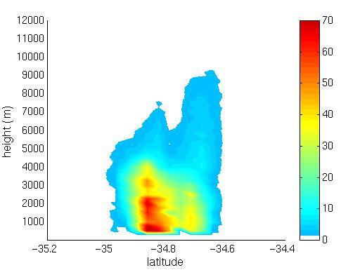
| Longitudinal profiles of the vertical rain rate were analysed at 50 km increments across the heavy rainfall event. Convective rainfall was found at a maximum vertical height of 6000 m. This product does not give the precipitation rate in the first 100 meters of the atmosphere. The bulk of precipitation in the atmosphere ranged from 1000 to 5000 m. The area of heavy rain between 34 and 34.5 S corresponds well to the high SST region. That significant amounts of rain were observed at high levels in the atmosphere above the Agulhas Current suggests that the moisture available from this current is convected upward and condenses, thus releasing latent heat which in turn increases the kinetic energy of the system. It is this increase in kinetic energy which can be measured as the latent heat release and in this form is available in the atmosphere to warm the surrounding air. This in turn causes enhanced instability and thus fuels the convection process. |
 |
|


[Abstract| Introduction| Agulhas Current | TRMM SST| Cloud Lines | Questions| Synoptic settings.| Rainfall| Visible Meteosat| Infrared Meteosat| The Movies| TRMM Orbits| TRMM Precipitation| TRMM zoom|
 TRMM vertical section|
Humidity flux 1|
Humidity flux 2|
Humidity flux vertical sections2|
Conclusion|
References
Thanks]
TRMM vertical section|
Humidity flux 1|
Humidity flux 2|
Humidity flux vertical sections2|
Conclusion|
References
Thanks]
Email: rouault@physci.uct.ac.za
Forum