| TRMM Precipitation zoom |
|---|
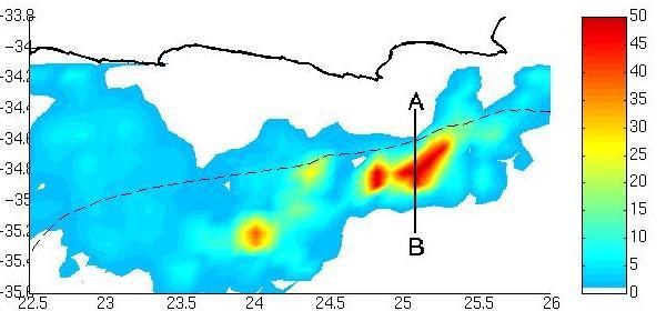
| From 08:49 until 08:53 of 15 December the TRMM passed over the Agulhas Current and provided imagery of heavy rainfall available from both the PR and TMI swaths. This event had a square area of approximately 45 000 km2 with a maximum surface rain rate of 28 mm/h according to TMI and 94 mm/h according to the TMI/PR combined product (PR has a better spatial resolution). |
 |
|


[Abstract| Introduction| Agulhas Current | TRMM SST| Cloud Lines | Questions| Synoptic settings.| Rainfall| Visible Meteosat| Infrared Meteosat| The Movies| TRMM Orbits| TRMM Precipitation|
 TRMM zoom|
TRMM vertical section|
Humidity flux 1|
Humidity flux 2|
Humidity flux vertical sections|
Conclusion|
References
Thanks]
TRMM zoom|
TRMM vertical section|
Humidity flux 1|
Humidity flux 2|
Humidity flux vertical sections|
Conclusion|
References
Thanks]
Email: rouault@physci.uct.ac.za
Forum