General Description of the Maps
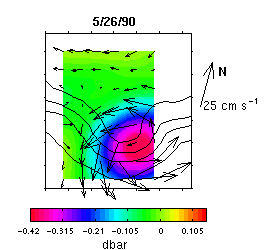 Plan-view
maps showing three different fields:
Plan-view
maps showing three different fields:
-
Pressure field anomaly at 3500 m in color
-
Depth of the 12
oC isotherm contoured
at 200 m intervals
- Velocities vectors at 3500 m with speeds proportional to compass arrow length
The maps are for 1200 UT on the date indicated.
Tick marks are at 50 km intervals.
Each frame corresponds to the larger box and the color-shaded region to the smaller box in the array figure.
 | Cyclones/Troughs | Anticyclones/Crests
| WCR | TRW
| Cyclones/Troughs | Anticyclones/Crests
| WCR | TRW