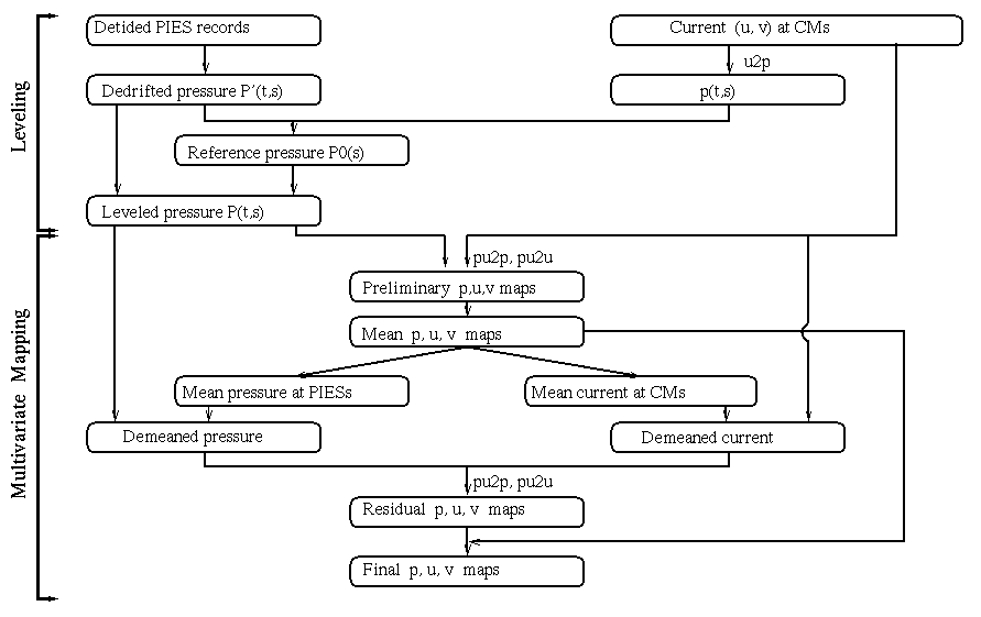
Leveling and Multivariate OI Mapping
- Pressure records were referenced to the same absolute geopotential using the measured abyssal mean geostrophic currents
- Leveled pressures combined with current measurements in a multivariate optimal interpolation (OI) mapping
-
Produced daily maps of the pressure and current fields at 3500 m.
Flowchart of steps | Map Verification
Postscript texts:
Detailed description | Covariance Functions
Leveling the Pressure Records
Steps:
- Measured currents alone are OI mapped to produce streamfunctions p(t,s) at pressure measurement sites s
- Subtract measured pressure P(t,s) and p(t,s) for each site s from those at one designated site s1
- Reference level at each site is the time average of the differences of these residuals
Assumptions:
- The mean abyssal currents are geostrophic
- The dynamic pressure at the ocean bottom does not change (other than hydrostatically) from its geostrophic values just above the bottom boundary layer
- The vertical shear of the currents at 3500 m is small so that horizontal pressure gradients at the bottom are the same as at 3500 m
Why Use Multivariate Optimal Interpolation?
If pressure maps from measured currents only:
-
Spatially consistent
-
Temporally inconsistent
-- velocities determine only pressure gradients
-- reference level differs for each map
Or if pressure maps from measured pressures only:
-
Temporally consistent
-
Spatially inconsistent
-- reference level differs for each site
Advantage of combining currents and pressure:
- Spatially and temporally consistent maps are produced
- Improved resolution since both the pressure and its gradients are used as inputs
- Geostrophically-constrained maps are obtained by the choice of covariance functions (postscript file)


![]()