 |
Abyssal cyclone developing under a steep upper-jet trough
Highly energetic features observed in the SYNOP Central Array were intense cyclonic circulations around deep low pressure (LP) centers. These strong cyclones only occurred when steep meander troughs formed in the upper jet.
|
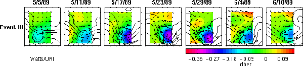
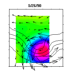
A typical meander trough and deep cyclone event. On May 5th a small-amplitude meander in the upper layer propagated over a weak LP cell in the lower layer. Over the subsequent 3 weeks, the upper meander trough stalled and amplified, and the deep LP center intensified. During the development phase, the center of the deep cyclone was shifted offshore and slightly downstream of the upper trough, a characteristic signature of baroclinic instability. The currents in the cyclone reached maximum speeds of 45 cm s-1 . The cyclone currents are nearly barotropic (weakly depth dependent), as shown by Savidge and Bane (1999a) .This nearly barotropic cyclonic flow crosses the flow of the upper baroclinic jet, veering to the left or right in different phases of the meander. Significant cross-frontal flow is readily observed in all the frames. By June 4th the vertical tilt against the mean shear decreased to zero and further development ceased. After June 6th, the cyclone weakened and the trough relaxed.
Luyten (1977) also measured currents in excess of 0.3 m s-1 under the Gulf Stream near 70oW. He also mapped the deep streamfunction fields, which revealed eddy-like circulations. However, their relationship to the upper jet went unrecognized.


