Uchida et al.,
Kuroshio transport south of Japan estimated from in situ oceanographic data and satellite altimeter data

TIME SERIES


The relationship between the Kuroshio transport and the sea level difference across the Kuroshio (Fig. 4a) and TOPEX/POSEIDON altimeter data* (Fig. 5) provide us with a time series of the Kuroshio transport for seven years (Fig. 6a). It shows large fluctuations (standard deviation is 11 Sv) around an average of 57 Sv. Most of the fluctuations are associated with fluctuations of both the stationary and propagating eddies superimposed on the Kuroshio system. The transport of the Kuroshio recirculation is estimated in a similar way using altimeter data and the relationship between the transport and sea level deference obtained for the Kuroshio recirculation region. Here the Kuroshio recirculation transport is estimated between the offshore edge of the Kuroshio (Fig. 5) and 26 degrees north latitude. The throughflow transport of the Kuroshio is estimated by subtracting this recirculation transport from the above-estimated Kuroshio transport (Fig. 6b). The average is reduced from 57 Sv to 42 Sv and the standard deviation is also reduced from 11 Sv to 9 Sv.

* NOTE: The presently available geoid model is not accurate enough to be used with the altimeter data in order to estimate the absolute SSDT (deviation of the sea surface from the geoid). Therefore only anomalies from the temporal mean are usable in the altimeter data. In this study, the temporal mean SSDT profile along the track was estimated as follows. At location x and time t, the absolute SSDT(x,t) is written as follows;
SSDT(x,t)=SSDT_mean(x)+SSDT'(x,t).....(1)
where SSDT_mean(x) is the temporal mean SSDT, SSDT'(x,t) the fluctuation SSDT. 
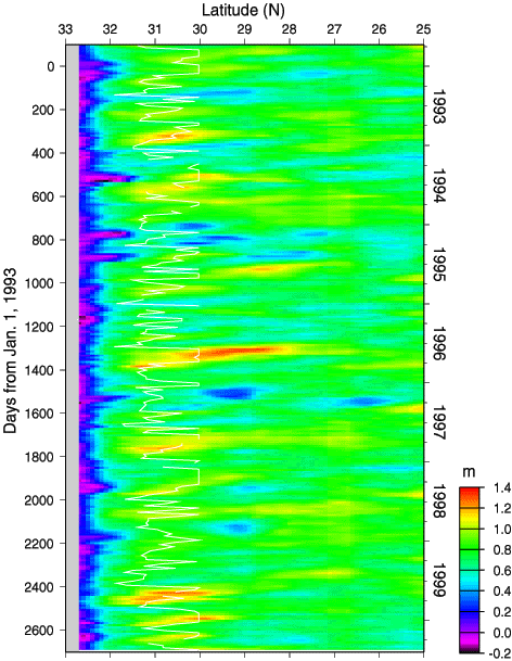
The SSDT(x,t) profile was estimated repeatedly from in situ oceanographic data (Fig. 3c), referred to the tide gauge data at Cape Ashizuri. SSDT'(x,t) profile was derived from the altimeter data. Using those profiles, the unknown SSDT_mean(x) profile was estimated from Eq. (1), using the least-squares method. The sum of the resulting SSDT_mean(x) profile and a SSDT'(x,t) profile from the altimeter data gave a accurate individual absolute SSDT(x,t) profile.

Fig. 5.
Time-latitude plot of SSDT along the ASUKA line during 1993-1999. The plot is drawn on the basis of the TOPEX/POSEIDON altimetry data (with a ten-day interval) combined with in situ oceanographic data mentioned-above. White line shows offshore edge of the Kuroshio defined in this study (maximum position of the SSDT at north of 30 degrees north).
Fig. 6.
Time series of the Kuroshio transport (solid line with dots) south of Japan during 1993-1999, estimated from TOPEX/POSEIDON altimeter data using the relationship between the transport and SSDT difference (Fig. 4a). A 3-point low-pass filter with weights (0.25:0.5:0.25) has been used. Panel (a) is the transport of the Kuroshio as the eastward flow. The seven-year mean of the transport is 57 Sv with a standard deviation of 11 Sv. Also shown are transports (circles) estimated from in situ data. Panel (b) is the transport of the Kuroshio as the throughflow. The seven-year mean of the transport is 42 Sv with a standard deviation of 9 Sv.


[ Top | ASUKA | Kuroshio transport | Time series | Seasonal signal | References ]