Introduction
|
The Kuroshio Extension and its Northern Branch east
of the Bifurcation Point represent the northern boundary
of the warm water carried by the subtropical gyre.
|
The variability in position and transport of these currents
has significant impact on the sea surface temperature and heat content
anomalies in the region, and thus on climate (Qiu, 2000).
|
Here we use TOPEX/POSEIDON altimeter data from October 1992 to
August 1999 combined with climatological data within a two-layer
reduced gravity model to identify the Kuroshio Extension, its
Northern Branch, and Bifurcation Point from the Japanese Coast eastward
to 175°W. Baroclinic volume transports of the current system
are also estimated.
|
|
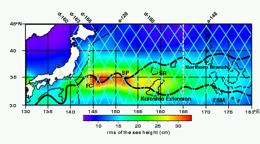
Path of the Kuroshio Extension and its Northern Branch
The Kuroshio Extension separates from the Japanese coast
near 35°N becoming a meandering eastward current
with two quasi-stationary meanders at 144°E (First Crest, FC)
and 150°E.
The widening and weakening of the current to the east of these
meanders is linked to the main bathymetric features, Shatsky Rise (SR) and
the Emperor Sea Mounts (ESM).
The Kuroshio Extension bifurcates between 150° and 165°E
(Mizuno and White, 1983).
The main Kuroshio Extension flows eastward and is easily recognized
until reaching the Emperor Sea Mounts, while its Northern Branch
flows northeast along the Shatsky Rise (Levine and White, 1983;
Mizuno and White, 1983) approaching the subarctic front
(Kawabe and Taira, 1998).
|