Hydrographic Data
|
|
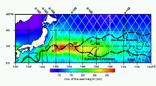
Meridional dashed white lines at 144° and 165°E
show the CTD sections.
|
Seasonal CTD sections from the R.V. Kofu Maru along 144°E
from 34° to 42°N with 20 mile station spacing were used
to identify the path of the Kuroshio Extension at the first crest (FC)
(JMAa,1992-1999).
|
CTD data used to identify the Kuroshio Extension downstream and its
Northern Branch was obtained by the R.V. Ryofu Maru along 165°E from
30° to 45°N (JMAb, 1998-1999).
Additional data from the R.V. Hakuho Maru
(University of Tokyo) along 165°E in 1993 (Taira and Kawabe, 1994) were
also included in the time series.
|