Altimeter Data
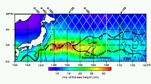
Selected ascending and descending groundtracks of the TOPEX/POSEIDON altimeter (T/P) (light blue). The background scale shows the rms of the sea height obtained from the T/P altimeter data for the study period.

Altimeter Data |
|
|
|
Selected ascending and descending groundtracks of the TOPEX/POSEIDON altimeter (T/P) (light blue). The background scale shows the rms of the sea height obtained from the T/P altimeter data for the study period. |
|
|
|
|
|

|
|

|
|
|
|

| |||