Gridded Data Products
• Gridded Data Products (GDPs) are distributed here primarily to make these ferry-based measurements available ( disclaimer) to researchers in a convenient and useful format. For example, numerical modelers can use the GDPs to improve fidelity of hydrodynamic simulations used for water quality management purposes.
• The GDPs have been created, from the raw measurements, through a series of processing stages including quality control that removes data not deemed of sufficient quality. For details, see the technical report. ( Download technical report as PDF. [get free Adobe
Acrobat Reader, needed to view PDF files]). To obtain data from other processing stages, email foster@gso.uri.edu.
• The map below shows where the fixed GDP grid locations, or “virtual stations”, are located (superposed on the 20/40/60/80-meter bathymetric contours). There are 18 grid locations: one (named “G01”) in Plum Gut, and 17 (named “R01” – “R17”) spanning The Race.

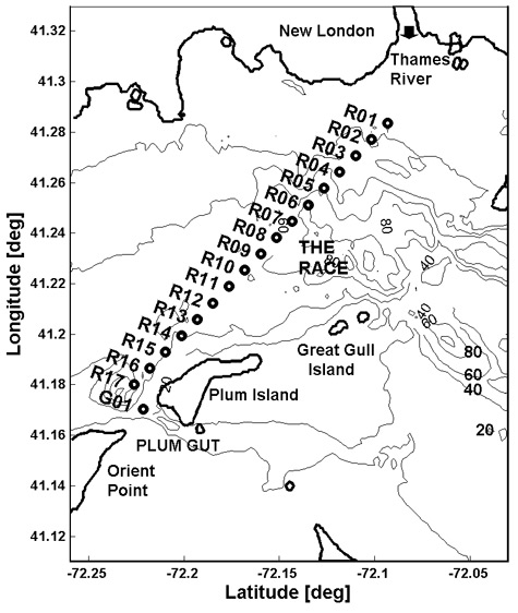
• GDPs consist of archived observations, to which additional data are periodically appended as they become available. In its present implementation this website is not intended to serve data in real time. To date, the most recent data the velocities GDP contains are from December 2006; the most recent data the water properties GDP contains are from September 2006.
• Gaps in the record of a few hours to a few days are due to poor data
quality, which generally arises in association with a rough sea state.
Gaps of weeks to months correspond to periods when the sensors required
maintenance and were not sampling, and/or to periods when the vessel
underwent maintenance work and was not operating.
• Various GDP files may be downloaded. Each file is available in two formats: ASCII (text format) and MAT (binary Matlab format; version 7 or higher of Matlab is required). A header or “readme”, with explanations of the data content and format, is provided in each file. Certain browsers may require you to use the right-click menu to properly download the files.
COMPLETE SUBSET OF FILES FOR BOTH GDPs
A minimal subset of files, containing a single non-redundant set of all GDP data values, consists of: (a) the grid information file, (b) the 18 time-sequence files for water velocity profiles, and (c) the 18 time-sequence files for the near-surface water properties. This complete subset, together with a PDF of the technical report, is available here as a compressed "zip" file:
FOSTERLIS_CompleteSubset_Ascii_May2007.zip (about 15 megs)
FOSTERLIS_CompleteSubset_Matlab_May2007.zip (about 22 megs)
GRID INFORMATION
(Latitude, Longitude, Depth Intervals, Bathymetry)
Download as ASCII file, 3kb
Download as MAT file, 2kb
WATER VELOCITY PROFILES GDP
Multi-Year Time Sequences from Individual Grid Locations
ASCII file sizes: up to 10 megs
MAT file sizes: up to 2 megs
G01vel.asc G01vel.mat
R01vel.asc R01vel.mat
R02vel.asc R02vel.mat
R03vel.asc R03vel.mat
R04vel.asc R04vel.mat
R05vel.asc R05vel.mat
R06vel.asc R06vel.mat
R07vel.asc R07vel.mat
R08vel.asc R08vel.mat
R09vel.asc R09vel.mat
R10vel.asc R10vel.mat
R11vel.asc R11vel.mat
R12vel.asc R12vel.mat
R13vel.asc R13vel.mat
R14vel.asc R14vel.mat
R15vel.asc R15vel.mat
R16vel.asc R16vel.mat
R17vel.asc R17vel.mat
Individual Ferry Crossings (All Grid Locations)
(Response can require up to a minute or longer; be patient!)
(Also, at the moment this loads properly in Firefox but not Internet Explorer.)
Preview &/ Download: Browsable Tree
|