|
What have we learned from FOSTER-LIS so far?
- Tidal currents in eastern LIS negotiate complex coastline geometry and seafloor topography. They are
- swift, reaching up to about 80-100 centimeters per second (nearly 2.2
miles per hour)
- oriented along the estuary axis nearly east-west
- generally strongest in the deepest central portion of the estuary and in Plum Gut, the narrow gap between Orient Point and Plum Island
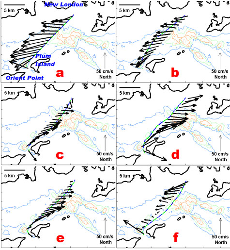
(Figure above:) Observed flow over a tidal cycle. Currents are averaged
vertically using all sampled depths. Six non-sequential crossings were
selected, from a period of many days, to nearly uniformly span a
12.4-hour tidal cycle: delay relative to most recent high tide is about
(a) 0, (b) 2, (c) 4, (d) 6, (e) 8, (f) 10 hours. Purple-green hatch line
is ferry path. Colored lines are constant-depth contours (blue 20m, red
40 m, etc.) to show seafloor depth variation.
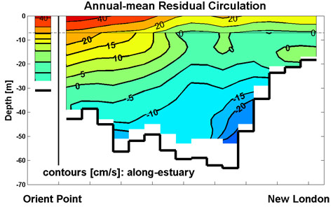
(Figure above:) Residual currents are non-tidal net drift, an average over at least several tidal cycles-- in this case, about 2500 ferry
crossings spanning two years. Currents in the along-estuary (roughly
east-west) direction are shown, more red where directed eastward out of
the estuary and more blue where directed westward in to the estuary.
Currents shallower than 7 meters deep are not measured by the ferry and
have been inferred by assuming the simplest spatial structure and
matching total inward and outward flow to conserve volume. An across-estuary vertical slice from Orient Point at left to New London at right is seen, looking westward, with the black vertical line at Plum Island.
- Residual flow: non-tidal currents
- Eastern LIS residual flow was poorly known previously. Isolating it requires sampling multiple times daily, for many days or weeks, to average out stronger alternating tidal motion. Ferry-based measurements are uniquely suited to accomplish this.
- Observed residual currents peak at about 30-60 cm/s. Eastward flow exits LIS concentrated along the north shore of Long Island near the surface. Westward flow enters LIS concentrated along the bottom near the Connecticut side.
- The volume of inward and outward flows in this estuarine exchange flow is roughly 20 times the annual-mean river inputs to LIS.
- The left-right asymmetry indicates the influence of the Coriolis effect (see Estuarine Physical Oceanography).
- These observations provide a new perspective on pathways and rates of water replenishment in LIS. They can support water quality management decisions by helping validate computer simulations of circulation.
- For more information, see: Codiga, D.L. and D.A. Aurin, 2006. Observed residual circulation in eastern Long Island Sound: transverse-vertical structure and exchange transport. Cont. Shelf Res., 27(1), p103-116.
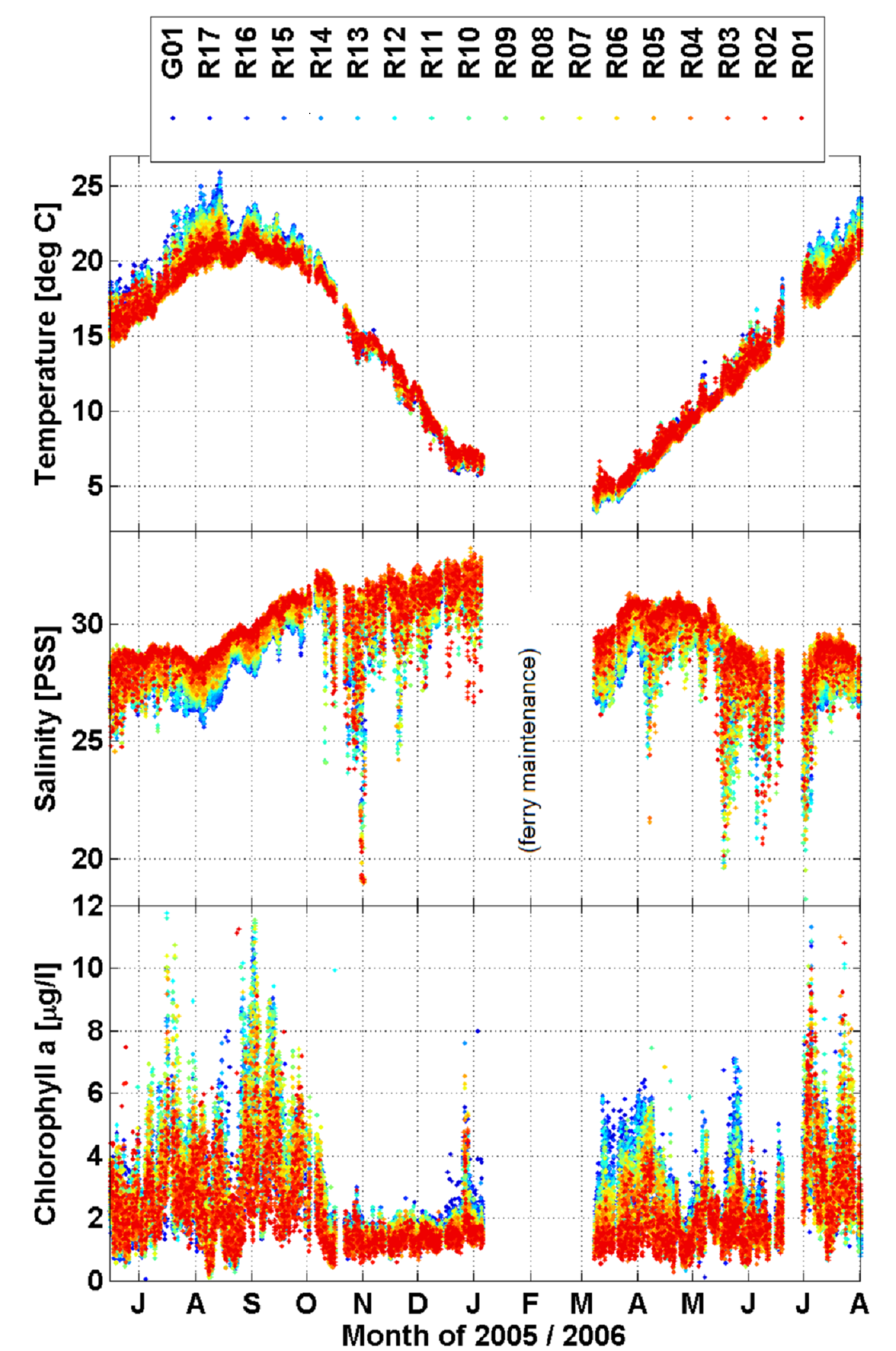
(Figure above:) Ferry-observed 2005-2006 seasonal cycle of near-surface temperature, salinity, and chlorophyll concentration, color-coded by position across the sound (blue nearest Orient Point in the south, and red nearest New London to the north; upper legend shows station names as in map). Observations from 2010-2011 (not shown) of temperature and salinity share similar features and also support the conclusions listed below.
- Surface water properties: Seasonal and across-sound changes
- Temperatures progress regularly between 3-5 C in winter and 20-25 C in summer. Relative to northern sites, temperatures at southern sites are 3-5 C warmer in summer and 1-2 C cooler in winter.
- Salinities are influenced by river runoff. Minima are seen in Oct-Nov 2005, an unusually wet fall. Through the year, southern sites are 2-4 PSS fresher than northern sites.
- Chlorophyll concentration, indicating phytoplankton abundance, is elevated and variable during non-winter months. This suggests continuing irregular population growth, as opposed to a single springtime "bloom". Chlorophyll at southern sites is generally higher than northern sites year-round.
- Differences at southern sites relative to northern sites (warmer summer, cooler winter; fresher and higher chlorophyll year-round) are similar to LIS properties far west of the ferry path. This is a result of the water at southern sites originating farthest to the west, as implied by measured residual flow (described above) most strongly eastward in the south.
- Knowledge these data help generate, for example the quantitative view of properties of water flowing eastward out of LIS, is useful in improving water quality management efforts.
|