Dynamic Heights continued
|
Applying this linear relationship to the IES measured
tau' data, we obtain time series of D'
at each mooring site. So long as the reference depth is not too
shallow, the value of m does not depend
significantly on this depth. Hence, although
m was not determined for a reference depth of
800 dbar, we can apply this value to the IES measured
tau' time series to obtain D' time
series for the same (full-water-column) reference
depth. Also, D'800 values can be
calculated from hydrographic profiles taken in
the vicinity of the IES moorings. All these
data can be compared to sea surface height (SSH) fluctuations
calculated from the TOPEX/POSEIDEN (T/P) altimeter data
along a groundtrack through the ASUKA line.
|
|
|
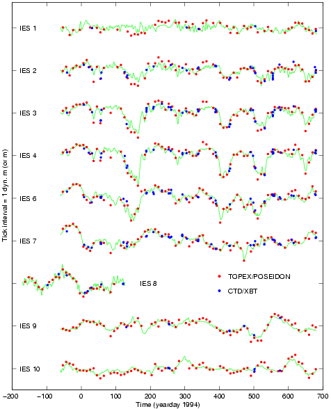
Time series of D'800 from IES data (green lines) shown with
measured D'800 from CTD/XBT casts
(blue dots) and measured H'
from the T/P altimeter (red dots). The T/P altimeter data were
spatially interpolated to determine the values at the IES locations.
For each of the nine traces, the set of blue dots and the set of red
dots have each been positioned vertically so that the average of the
set corresponds to the average of the green trace sampled at the same
times.
|
There is generally good agreement between the
three quantities. A portion of the
differences may be due to the fact that we are
comparing D800 with SSH measurements.
Teague et al. (1995) found good agreement
between IES determined height anomalies and
T/P measurements near the Kuroshio separation
point. The regression statistics
(table)
for our comparisons in the ASUKA region are similar to
their results.
|
Big meanders of the Kuroshio are evident from
these records near yearday 100, before yearday
400, and before yearday 500. The large drops
in height that occur at mooring sites 3-6 are
caused by offshore movements of the Kuroshio.
|
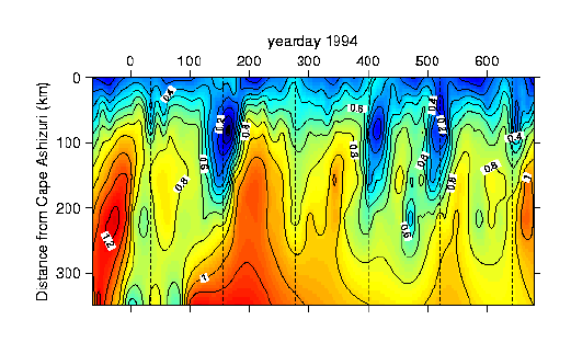
By using the concurrent hydrographic data to
estimate mean values for D800
(figure) and adding these values
to the IES determined D'800, we produced
time-distance maps of D800.
|
|
|
Time series of D800 for
the region where the Kuroshio crosses the
ASUKA line. The distances shown are along the ASUKA line (oriented
toward 155°True). Contour intervals are 0.1 dyn. m.
A value of 1.2 dyn. m was subtracted from D800
so that the minimum of the figure occurs at zero. The color palette was
chosen for visual clarity. Dashed lines are at 1/3-year intervals
starting at 1994 February 4.
|
The contour lines of D800 from this map
can be viewed as streamlines. The closely
spaced contours indicate the main Kuroshio
flow. The three large meanders are clearly
seen as the Kuroshio moves from an offshore
distance of 50 km to an offshore distance of
175 km within a few days. Other meanders and
disturbances are also evident from this map.
|
Through 1994 and 1995, meanders appear to have
occurred at regular intervals. The dashed
lines in the above figure are drawn with
exactly 4 months separation and are positioned
to best coincide with the meander events.
Although each event is of a variable duration
and strength, meanders occur only near the
time-periods marked by the dashed lines
(February, June, and October).
|