Mean flow at intermediate depth

A first estimate of the mean flow was made by box averaging float data in 2° longitude by 4° latitude bins.

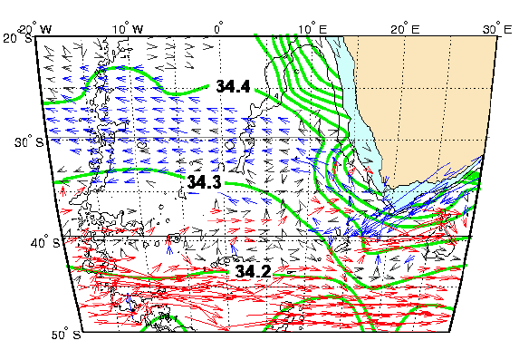
Mean flow superposed to salinity on the 27.2 sigma theta. Arrows are grey if speeds are less than 2.5 cm s-1 and in colour if greater. Red and blue arrows indicate negative and positive zonal components, respectively. Green lines indicate isohalines.

The Agulhas Current (swift south-westward flow along blue arrows) dissolves near the Agulhas Retroflection (40° S, 20° E).

MEAN FIELD

The Agulhas Return Current (eastward flow along red arrows) emerges downstream of the Agulhas Retroflection after a northern circumnavigation of the Agulhas Plateau.

A separation between the Agulhas Return Current and the combined South Atlantic/Antarctic Circumpolar Currents is indicated east of 20° E by the diffuse flow field between 40-45° S.

Mean flow at intermediate depth and its relationship to the salinity field

There is a strong association of the westward flow field with the S =34.3 to 34.4 regime in the Namibia Abyssal Plain and southern Angola Basin.

Mean flow superposed to salinity on the 27.2 sigma theta. Arrows are grey if speeds are less than 2.5 cm s-1 and in colour if greater. Red and blue arrows indicate negative and positive zonal components, respectively. Green lines indicate isohalines.

The zone of sluggish and undirected flow around 40° S in the Cape Basin suggests that a continuous advective connection between the eastward flowing southern limb of the subtropical gyre and the Benguela Current does not exist.

MEAN FIELD

The source of the water flowing in the Benguela Current appears to be an approximately equal mixture of Indian Ocean and Atlantic intermediate waters which convergence at the Agulhas Retroflection.

PROBLEM RAFOS FLOATS MEAN FIELD MESOSCALE MEANDERS AND RINGS
HOME