Introduction

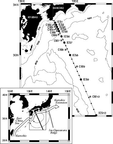
This poster examines the occurrence of Kuroshio small meanders and transport variations in the region south of Shikoku, 350 km downstream of the Tokara Strait. Data were collected in an intensive collaborative study called ASUKA (Affiliated SUrveys of the Kuroshio off Ashizuri-misaki). These data consist of inverted-echo-sounder (IES) records, TOPEX/POSEIDON (T/P) altimeter records, CTD and XBT hydrographic casts, and moored-current-meter measurements, all of which we have used to derive time series of dynamic height, velocity and temperature sections, transports, and Kuroshio position.

Geographic locations of principal ASUKA measurements. Solid circles (large or small) mark sites where hydrographic profiles were usually taken. The larger solid circles also indicate the sites of IES's. Bull's eyes are current-meter-mooring sites. Current-meter moorings with asterisks (CM2 and CM4) were topped by upward-looking ADCP's. Solid line indicates the main ASUKA line. The T/P track is parallel to this line and lies approximately 8 km to the west-southwest. Lower panel shows a sketch of the mean Kuroshio path and recirculation in this region.

NEXT: Introduction continued

Abstract

Introduction

Dynamic Heights

Velocities

Transports

Conclusions

References

Home