The
overall goal of KESS is to identify and quantify the dynamic and
thermodynamic processes governing the variability of and the
interaction between the Kuroshio Extension and the
recirculation gyre.
The Kuroshio Extension System Study (KESS) 2-year field program began Summer 2004 with two deployment cruises. A summary map and an overview of each leg follows.
The first leg, 24-April (noon) to 1-June 2004 (8 AM), involving 38 at-sea days, departed from and returned to Yokohama, Japan. Randy Watts served as chief scientist, with co-PI Kathy Donohue (both from Univ. Rhode Island). Our main objectives were:
We experienced a number of serious difficulties with the CPIES instruments during the cruise (and fixed them, as detailed elsewhere). The instruments have a new acoustic telemetry capability, which reports on the data-quality immediately after launch, and if the ship returns at a later date can also transmit all the processed data for the intervening days. It was the acoustic telemetry that both made us aware of the problems and, after they had been fixed, gave us confidence that by the cruise end the instruments were all performing properly. Three instruments were lost or destroyed early in the cruise due to seawater leaks. One of the instrument-housings that had leaked was tested by lowering it repeatedly on the CTD wire. We isolated the leak to a vacuum port o-ring, and in particular, to dimensional variability in the titanium screw which retains it. [The supplier had changed its design. Knowing what to look for, we avoided these leaks for the rest of the deployments. ] The acoustic detector circuits were too sensitive to ambient noise on many of the instruments, requiring that a "squelch" level be tested on all of them and readjusted. It was necessary for us to recover and replace six instruments that had already been deployed to correct this problem.
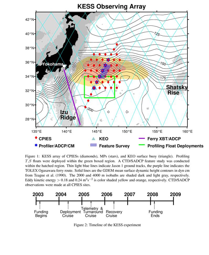
By the end of the cruise we had deployed CPIES at 46 sites (Figure 1), all of which gave good telemetry of all measured variables (tau, P, speed, direction) after they had settled onto the sea floor. In addition, on the final transit across the array enroute back to Yokohama, we were able to pass over and collect 8-to-14 days of data-telemetry from 9 of the sites. This was 100% successful – leading to good confidence that the difficulties had been solved.
The Kuroshio feature survey consisted of four transects on a meander-segment leading from a crest into a trough, where we hypothesized that mesoscale-driven cross-frontal flow would carry cold fresh waters from north of the Kuroshio across-stream to its southern side at Intermediate Water depths. The CTDs were spaced 15 km across-stream and transects were separated about 30km alongstream, seeking to observe coherent intrusions laterally and along-stream, and to relate them to the synoptic and small-scale current structure observed by the deep-reaching ADCP. The CTD (run by Scripps ODF) and ADCP (RDI Ocean Surveyor, 75kHz) systems worked very well, and initial analyses suggest that we found a strong coherent intrusion of Intermediate Water to study.
This leg departed Yokohama of the R/V Thompson late afternoon on June 5, 2004 and returned in the afternoon of June 19, 2004. Nelson Hogg served as Chief Scientist and was assisted by scientists and colleagues from a variety of institutions including WHOI, the University of Hawaii, the University of Hokkaido, the US Navy base in Yokosuka, the US Coast Guard and NOAA-PMEL.
The objectives of this leg were:The first mooring operations appeared to by going along routinely until we were notified by our support people back at WHOI that they were receiving satellite messages from a transmitter that was attached to the topmost flotation element on the first mooring that had been deployed. As this sphere was intended to be at 250m depth this meant that the mooring had failed. We then began to hear from the 4th mooring as well. Recovery of the top part of these moorings revealed that the wire had snapped and, after considerable thought, we came to the conclusion that the anchors were too heavy. In order to prevent the moorings from “walking” under the influence of the strong currents the anchors had been specified at 4500lb, some 900lb heavier than normally used. The mooring design programs indicated no problem as the breaking strength of the wire is around 8000lb but clearly the transient loads on anchor launch were exceeding this. We reconfigured the moorings, essentially by redistributing the buoyancy and adding extra instrumentation. Then, without further problems, we reset one of the two failed moorings (C4, we had just one spare anchor) and the remaining 3 moorings.
After the last moored profiler mooring we set a surface mooring which contained air-sea flux instrumentation as well as temperature and salinity measurements in the upper 500m.
Along the mooring line several of the Apex floats were released. At the completion of the mooring work the remainder were deployed in a closed cyclonic feature to the east of the moorings and in a larger anticylonic recirculation to the west on our transit back to port. The location of these features had been determined by receiving up-to-date information on the sea surface height on board ship obtained from a numerical model that was assimilating altimeter observations.
Full-depth CTDs were taken near each mooring and either full-depth or shallower CTDs were also taken in between moorings. As in the 1st leg the ADCP was run continuously and several highly detailed velocity sections were obtained across the Kuroshio.
KESS home page
Return
to
the Dynamics of Ocean Currents and
Fronts Homepage
Last Updated:September 2006