Introduction continued
|
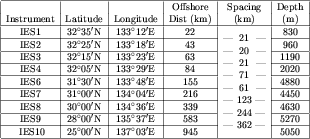
An array of ten IES's was deployed during 1993-95 along 1000 km of a
TOPEX/POSEIDON satellite altimeter groundtrack running southeast from
Cape Ashizuri on Shikoku Island, Japan.
Eight of these IES's were from the University of Rhode Island (URI)
and two (IES5 and IES8) were from the Japan Maritime Safety Agency,
Hydrographic Department. IES5 was not recovered.
Every hour, the IES's emitted a group of twenty-four 10 kHz pings at
10-second intervals and recorded the individual ping echo times from the
ocean surface. The median of the group of twenty-four times,
excluding unreasonable values, was taken as the representative echo-time
(tau) measurement for that hour.
The tau data were low-pass filtered using a Butterworth filter
(run forwards and backwards to preserve phase) with a 120-hour
cut-off period and subsampled at daily intervals. The processing generally
followed the procedures described in Fields et al. (1991).
Only variations about the mean were used for analysis because the
IES's lacked pressure sensors and therefore their depth could
not be determined accurately.
|
|
Locations and depths of IES instruments on the ASUKA line.
Offshore distance is measured from Cape Ashizuri
(32°44'N, 133°01'E) along the ASUKA
line oriented toward 155°True.
Spacing is the distance between instruments measured along that line.
The depths are given to the nearest 10 m.
|