We propose to study mesoscale variability in the southwestern portion of the Japan/East Sea (JES), with an array of 25 pressure-gauge-equipped inverted echo sounders (PIES) installed for two years. To reference these PIES measurements, we will also deploy 13 current-meter moorings (augmenting a set of 5 moorings being proposed by KORDI, WHOI and RIAM), and carry out 3 hydrographic surveys of the region. From these measurements, we will determine the gravest vertical structure of the current and temperature fields, and hence infer both shallow and deep current and pressure fields. We will produce daily regional maps of shallow and deep streamfunction, temperature, and vertical velocity fields, in order to understand the development and pinching-off of loops in the flow along the subpolar front and the coupling of the upper and lower layers during these processes.
We seek to understand the physics of the mesoscale circulation of the Japan/East Sea (JES), with a focus on the southwestern region where the variability is especially energetic.
We expect mesoscale variability to be most vigorous in the southwestern region of the JES, because this is the inlet region where the Tsushima Current forms three branches, and the two northern branches are reportedly very unstable. In particular, the northernmost branch, the East Korean Warm Current (EKWC), develops steep northward loops in the Ulleung Basin (UB) as it feeds into the strongly meandering subpolar front. The following goals are directed towards understanding the broad range of energetic mesoscale processes which we expect to be active in the region:
The Scientific Background and Technical Background sections amplify these goals and describe the techniques we will employ to achieve them. The Proposed Work section describes a specific program plan for achieving these goals.
The Japan/East Sea (JES) is a nearly enclosed sea that contains many processes observed in large-scale ocean basins. Flow enters the basin primarily at the southwestern corner through the shallow (sill depth 200 m) Korea/Tsushima Strait (KTS) from the East China Sea. Flow leaves the basin through three shallow, narrow passages to the northeast, the Tsugaru Strait which connects to the Pacific Ocean, and the Soya and Mamiya Straits, which connect to the Sea of Okhotsk. The general circulation in the basin brings cold waters southward along the Russian and North Korean coasts (Liman Current and North Korean Cold Current) and warm waters northward and eastward along both the South Korean and Japanese coasts (East Korean Warm Current and Nearshore Branch of the Tsushima Current). The East Korean Warm Current and North Korean Cold Current appear to meet at about 37N, where they leave the coast and enter the JES interior, forming the subpolar front. As it moves off towards the Tsugaru Strait at 41N, this front forms meanders with steep loops, shedding eddies.
In the southwestern JES, the flow through the KTS is called the Tsushima Current. This current carries a mean transport of about 2 Sv [Toba et al., 1982]. The overall seasonal variation appears to have a range of 0.7 Sv, with maximum transport in November--December and minimum in March--April. This is made up of a 1.3 Sv variation in the western channel and an out-of-phase 0.6 Sv in the eastern channel [Isobe, 1994]. The relative contributions of baroclinic and barotropic components can vary greatly. In summer the inflow is strongly statified due to surface heating and increased freshwater inflow; in winter it tends to be vertically well mixed. Moreover, warm water anomalies are found in the eastern channel of the Strait intermittently, due to warm water intrusions from the Kuroshio [Sugimoto, 1990].
After it leaves the KTS, the Tsushima Current is thought to form three branches [Kawabe, 1982a,b]. The first, called the Nearshore Branch (NB), comes from the eastern channel of the KTS and flows over the continental shelf off western Japan. It is thought to be topographically controlled. In general, the core velocities of 20--30 cm/s follow the 100 m isobath [Katoh, 1994]. The flow through the western channel of the KTS bifurcates variably around 36N to form the second and third branches, called the Offshore Branch (OB) and East Korean Warm Current (EKWC). The EKWC flows northward along the eastern Korean continental slope, turning offshore into an anticyclonic loop, which may pass south or north of Ulleung Island at about 37.5N. The portion along Korea is a western boundary current controlled by planetary beta. Geostrophic velocity estimates at the core of the EKWC are typically 50--70 cm/s (from thermal wind), but the actual velocities are expected to be higher when the barotropic components are included. Due to the shallow depth of the Tsushima Strait, most of the baroclinic struture of the EKWC is confined to the upper 300 m of the water column. A 19-level 1/3 degree numerical model of the JES developed by Yoon [1991] shows this western-boundary current to become broader with relatively weak vertical shear in winter and spring, and narrower with strong vertical shear and a southward countercurrent in summer and fall. But the horizontal resolution of this model may be too coarse for the results to be reliable: Hogan and Hurlburt [1997] have shown, in an implementation of the NRL Layered Ocean Model for the JES, that results are sensitive to grid spacing until the spacing is reduced to 1/32 degree, with a clear tendency of the EKWC anticyclonic loop to overshoot when the resolution is too coarse. A modeling study of the region by Isobe [1997] indicates that stronger stratification (larger g') results in an increased proportion of the Tsushima Current feeding into the EKWC in summer. The OB, found between the NB and EKWC, has core velocities of 25--40 cm/s and is frequently located near the Japanese continental shelf along the 100--200 m isobaths. But the OB has also been found farther offshore in deep water, where it effectively cuts across the neck of the looping EKWC. The great variability of the EKWC and OB---one or the other of them even being absent on occasion---is shown in Figure 1 (reproduced from Katoh [1994]). The three branches become indistinct and appear to coalesce in the region to the east of 132E.
Mesoscale variability in the JES is vigorous in the southwestern region. Here the Tsushima Current enters the JES and develops instabilities which produce much of that variability. In particular, bifurcation of the EKWC, reported to occur intermittently, results in the sporadic formation and pinching off of anticyclonic rings in the region near 37N, 131E [Katoh, 1994]. The kinetic energy and available potential energy (baroclinicity) transported into the region by the Tsushima Current are presumably responsible for the observed variability. Moreover, this type of vigorous baroclinic meandering is a likely source for the strong sub-thermocline eddy variability, which Takematsu et al. [1997] observed within the central JES (Figure 2).
A striking finding of SYNOP (a study of mesoscale variability in the Gulf Stream) was the strong linkage of the shallow and deep mesoscale eddy processes. The continuous w (vertical velocity) field and associated vortex stretching couples their dynamics. This process should also be active in the southwestern JES, accompanying meanders of the baroclinic fronts in that region. Moreover, being a small, relatively enclosed basin, the JES should be a particularly good region to isolate and study this vertical-coupling process, both observationally and numerically.
The JES is well suited for numerical circulation models. The Naval Research Laboratory Layered Ocean Model is currently being used to investigate the relationship between grid resolution, baroclinic instability, bottom topography, surface circulation and the model response to forcing by different wind sets. Resolution of the model is 1/32 degree and appears to produce realistic circulation patterns. The NRL model of the Yellow and East China Seas is currently being expanded to include the Japan/East Sea [Hogan and Hurlburt, 1997]. These modeling efforts will be linked with our in situ measurements. In addition, NRL analysis of altimetry data, currently ongoing in the Yellow Sea, will be extended to the JES.
This section motivates our proposed approach. The proposed 2-D array of moored measurements is expressly designed for the goals listed above, i.e., elucidate the mesoscale variability in the JES, determine the temporal development of the OB and EKWC, and provide the observational base for modeling and understanding the vertical coupling of the shallow and deep layers. The experimental design builds on our experience in other meandering baroclinic fronts (Gulf Stream, Subantarctic Front, North Atlantic Current, Kuroshio). Indeed, this JES study is an opportunity to address some of the most interesting new scientific questions that have arisen in the course of those earlier investigations. The approach and methods proposed are proven and well suited to address these issues in the JES.
The combined inverted echo sounder and pressure gauge (PIES) instrument measures the round-trip vertical acoustic travel time through the water column (VATT) and the abyssal pressure (P). From the resulting records we are able to determine dynamic height with precision of about 0.03 dyn m, and pressure with precision better than 0.001 dbar. The Paroscientific pressure gauge which we use in this instrument has excellent long-term stability, typically 0.01 dbar per year.
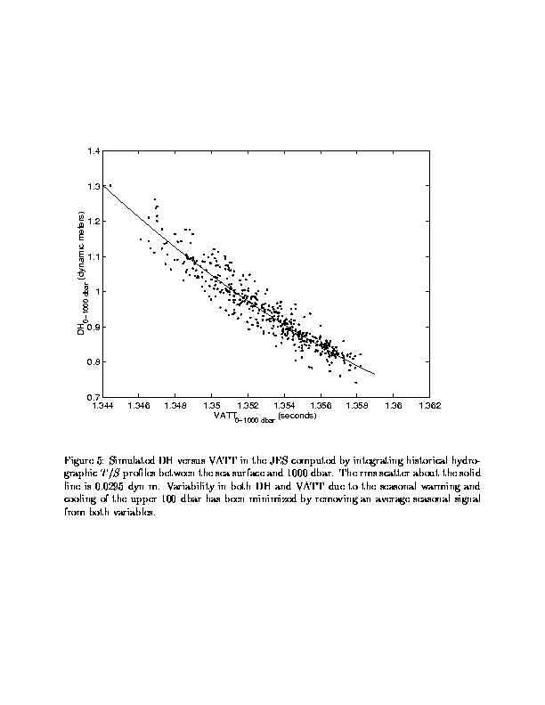
The VATT measurement is used to determine both the baroclinic temperature structure and the vertical profile of dynamic height (DH). This is an extension of the traditional interpretation, in which the VATT measurement is linearly related to the full-water-column DH [Watts and Rossby, 1977; James and Wimbush, 1995; Garzoli and Gordon, 1996]. In this generalized form, the DH-VATT relationship is non-linear, with curvature increasing when the limits of DH integration do not completely span the thermocline. He [1993] has demonstrated the ability of PIESs deployed in the Gulf Stream to determine DH on a variety of pressure levels. A key element for determining these DH-VATT relationships is the availability of a good set of historical hydrographic measurements, representative of the variability in the region. We have obtained a suitable set of hydrographic profiles for the southwestern JES from NODC, from which we have simulated DH-VATT relationships (shown later in Figure 5). Additional hydrography will also result from this Japan/East Sea DRI (see, for example, Section VI).
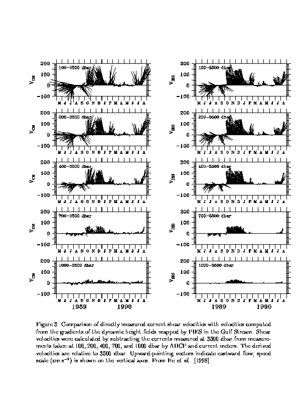
Using the horizontal gradients of DH profiles determined from neighboring pairs of PIESs, vertical profiles of the geostrophic baroclinic velocities normal to the gradients can be determined. Gridded PIES arrays yield both velocity components, since DH gradients can be determined in two directions. He et al. [1998] used these techniques to estimate the velocity profiles in the Gulf Stream and verified the results against independent current measurements (Figure 3). These techniques are currently being used in the North Atlantic Current and Subantarctic Front.
Two-dimensional arrays of PIESs were used in the Gulf Stream as part of the SYNOP and REX experiments [Shay et al., 1995; Watts et al., 1995; Hallock and Teague, 1995].
In REX, an array of 12 PIESs was used to map Gulf Stream position and direction at half-day intervals [Teague and Hallock, 1990]. Characteristics of the meanders, propagation and current direction, were measured and were found to be influenced by the New England Seamounts.
In SYNOP, daily maps of the thermocline depth field and bottom pressure field (Figure 4) were produced. The daily maps of the fields were constructed by combining the bottom pressure and deep current-meter velocities [Qian and Watts, 1992] in order to `level' the pressure measurements (referenced to the same geopotential).
These daily maps of the upper and lower layers in the Gulf Stream provided invaluable insights. Not only were we able to map out the path of the Gulf Stream thermal front, we could also simultaneously examine the abyssal layer. One of the primary results of the SYNOP experiment was the discovery of strong deep cyclones and anticyclones respectively beneath large amplitude meander troughs and crests. These eddies had strong current velocities (~50 cm/s). Although strong deep velocities have been observed before [Luyten, 1977], they were not previously known to be organized into well-defined cyclones and anticyclones. The temporal and spatial coverage of the SYNOP array allowed us to observe the development of these deep eddies and---of key dynamical importance---their phasing in relation to steep meander development in the upper layer.
Vertical motions, w, in the steep meanders were diagnosed by Lindstrom et al. [1997] using the adiabatic heat equation and a combination of PIES and deep current-meter measurements. The diagnosed w were calculated from 40-hour lowpass filtered data for single points in time. These were compared to vertical motions estimated from coincident RAFOS floats using 16-hour averages of w taken along the float tracks. Despite the sampling differences, the two estimates of w agreed well (r-squared of 0.73). Daily maps of the w field showed regions of upwelling and downwelling relative to meanders (Figure 4). Upwelling occurs exiting a meander trough (or entering a crest), and downwelling occurs entering a meander trough (or exiting a crest). The strongest w was located at the steepest thermocline slope and occurred in slowly propagating meanders. Strong events during which |w| exceeded 2 mm/s occurred nearly every week and persisted for several days at a time. Highly significant cross-frontal exchanges were shown to occur, associated with these large-amplitude meandering processes. Recently, the same process has been observed in meanders of the Subantarctic Front south of Australia [Watts et al., 1997], causing exchange of Intermediate Waters across the front.
Teague et al. [1995] analyzed Kuroshio sea surface height fluctuations observed simultaneously with IESs and TOPEX/POSEIDON altimetry. They found that these measurements are complementary in describing mesoscale variability. In addition, Teague et al. [1997] used IES measurements in conjunction with altimetry measurements to estimate the geoid along a section across the Kuroshio for which the accuracy was found to be better than 8 cm. The sea surface heights obtained by removing this geoid from the altimetry measurements produced good current speed estimates (about 0-1 m/s) for the Kuroshio across the section. In contrast, current speeds obtained across the same section by removing the GDR geoid [Callahan, 1993] from the altimetry data were very unrealistic (from -4 to +5 m s). These results highlight the need for long-term in situ measurements in order to obtain high quality sea-surface height estimates from altimeters.
The southwestern JES is well suited for the use of PIESs as observational tools. Figure 5 shows there is a good DH-VATT relationship in this region. The proposed 2-dimensional array of PIES will map the pathways of the EKWC and the OB when in its offshore location. We expect to see, in these daily maps, the process of formation and pinching-off of the EKWC loops reported by Katoh [1994]. Additionally, the bottom pressure measurements and deep current measurements will enable us to create maps of the deep pressure field. These will put into context the vigorous deep velocities observed by Takematsu et al. [1997] in the central JES, by observing the coupling of the lower and upper layers.
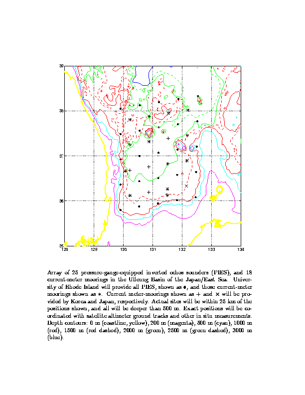
We propose to deploy a 2-D array of PIES instruments in the Ulleung Basin (UB) for a period of two full years. Array spacing has been chosen to match the eddy conditions in the region. We have estimated the scale of UB eddies in four different ways. (1) Stammer [1997] has shown the zero-crossing length (Lo) of the correlation function is approximately related to the radius of deformation (Ro) by
Lo = 0.8 Ro + 88 km
and with an estimated Ro = 15-20 km [Yoon, 1991], this gives Lo ~ 100 km. (2) In AVHRR images of the Japan Sea, Toba et al. [1984] found an SST k-spectrum peak indicating eddies with km size. (3) From the satellite-determined track of a drifter, Lie et al. [1995] determined that eddies in the UB characteristically have major and minor axes of about 120 km and 70 km. (4) In a 2-D hydrographic survey of the UB, Byun et al. [1997] found a warm-core eddy at 200 m depth just east of Ulleung Island with ~ 100 km scale. All four of these results suggest a typical mesoscale of 100 km. With neighboring elements spaced at approximately half this distance, an array will adequately sample the mesoscale eddy field. In our planned field program (Figure 6), we have 25 PIES instruments arranged in a 5 by 5 array, with 55 km zonal spacing and 60 km meridional spacing. This should allow coherent mapping of mesoscale features within the 220 by 240 km region enclosed by the array. Our plan is to deploy this array in the spring of 1999, and to recover it two years later in the spring of 2001.
In order to compute the deep and shallow current fields from the PIES data, we need, at a minimum, to measure the deep current velocity near each centerpoint of the grid of PIES sites, for a few weeks during the PIES deployment. To ensure success, we propose to do more than this minimum. Dr. Moon-Sik Suk at KORDI (Korea) is maintaining four deep current-meter moorings in the Ulleung Basin. Dr. Jong-Hwan Yoon of RIAM (Kyushu Univ., Japan) will be deploying one more such mooring. These will provide current data for 5 of the 16 sites which we need. To obtain measurements at the other 11 sites---plus 2 extra sites, see below---we propose to deploy 13 current meter moorings (Figure 6). These moorings will have a single Aanderaa current meter at 100 m elevation above bottom, well above the benthic boundary layer. The two extra sites (Figure 6) will be in areas with relatively steep bottom slopes. Their purpose is to provide additional spatial resolution in regions of possible narrow topographic currents.
On both cruises we will carry out a CTD survey, with a CTD profile taken at each of the 25 PIES sites. The data from these surveys will be used to refine the calibration of our PIES array and to compare our mapping techniques with traditional methods. Also, Drs. Kuh Kim (Seoul National Univ.) and Lynne Talley (SIO) are planning to take CTD sections along two lines through the Ulleung Basin in July 1999. These hydrographic and current data will provide useful supplementary comparisons with dynamic heights and currents computed from our PIES data.
In addition, we plan to make use of data from several other sources including the following:
We will need two cruises, each two weeks in duration, at roughly two-year intervals, ideally in May or June 1999 and 2001.
The two-week duration for each of these cruises is estimated on two assumptions: (1) Each cruise begins and ends at a nearby Korean or Japanese port (e.g., Pusan or Shimonoseki). (2) The ship permits round-the-clock operations. Additional time will be needed if either of these assumptions does not apply.
The calendar times for these cruises are flexible. The constraints are (1) that the time between the first and last cruises be between 2 and 2.5 years, and (2) that all the cruises be at times of the year when workable conditions can be expected (to facilitate mooring launch and recovery operations).
Ideally, CTD operations would be carried out using a standard SeaBird or Neil Brown system with conducting wire winch. But we have an internally recording SeaBird CTD that is completely adequate for our needs (dynamical, as opposed to water-mass tracing) and which can be used from almost any vessel.
The set of measurements proposed here is designed to meet the goals listed in Section III above. Goal 1 would be accomplished using absolutely referenced geopotential height and Fofonoff baroclinic transport streamfunction computed from the PIES and current-meter measurements. There is some additional transport over the shelf and upper slope regions on both the Korean and Japanese sides of the UB. It may be estimated from the difference in subsurface pressure () between coastal tide-gauges and the nearby PIESs. Altimeter tracks crossing the region will provide a complementary measurement. These estimates will be calibrated with ADCP measurements made close to the satellite tracks from a ship and perhaps from bottom mounted instruments.
Work summarized in Section V above has demonstrated that a PIES array is well suited also for Goals 2--4. The SYNOP experiment [Watts et al., 1995; Shay et al., 1995] mapped the shallow and deep mesoscale eddy fields as in Goal 2; a key finding in that work was the clear demonstration of vertical coupling and its dynamical importance to the development of upper jet meanders/loops/rings and deep eddies---as in Goal 3. Lindstrom et al. [1997] demonstrate the importance of mesoscale processes for vertical and cross-frontal fluxes---as in Goal 4.
Byun, S-K, C. Kim, K-I Chang and D. Jeon. Hydrographic characteristics observed near Ulreung Island in summer 1996. Proceedings of the CREAMS'97 International Symposium, 28--30 January 1997, Fukuoka, Japan, pp. 89--91, 1997.
Callahan, P. S. TOPEX/POSEIDON Project GDR Users Handbook. Rep. JPL D--8944, Jet Propulsion Laboratory, 84 pp., 1993.
Garzoli, S. L., and A. L. Gordon. Origins and varibility of the Benguela Current. J. Geophys. Res., 101, 897--906, 1996.
Hallock, Z. R., and W. J. Teague. On the meridional surface profile of the Gulf Stream at 55W. J. Geophys. Res., 100, 13,615--13,624, 1995.
He, Y. Determining the Baroclinic Geostrophic Velocity Structure with Inverted Echo Sounders. M.S. Thesis, Univ. R. I., Narragansett, 1993.
He, Y., D. R. Watts, K. L. Tracey. Determining geostrophic velocity shear profiles with IESs. J. Geophys. Res., 103, 5607-5622, 1998.
Hogan, P. J., and H. E. Hurlburt. Sea of Japan circulation dynamics via NRL layered ocean model. Proceedings of the CREAMS'97 International Symposium, 28--30 January 1997, Fukuoka, Japan, pp. 109--112, 1997.
Isobe, A. Seasonal variability of the barotropic and baroclinic motion in the Tsushima--Korea Strait. J. Oceanogr., 50, 223--238, 1994.
Isobe, A. The determinant of the volume transport distribution of the Tsushima Warm Current around the Tsushima/Korea Strait. Continental Shelf Res., 17, 319-336, 1997.
James, C. E., and M. Wimbush. Inferring dynamic height variations from acoustic travel time in the Pacific Ocean. J. Oceanogr., 51, 553--569, 1995.
Katoh, O. Structure of the Tsushima Current in the southwestern Japan Sea. J. Oceanogr., 50, 317--338, 1994.
Kawabe, M. Branching of the Tsushima Current in the Japan Sea, Part I. Data Analysis. J. Oceanogr. Soc. Japan, 38, 95--107, 1982a.
Kawabe, M. Branching of the Tsushima Current in the Japan Sea, Part II. Numerical experiment. J. Oceanogr. Soc. Japan, 38, 183--192, 1982b.
Lie, H-J, S-K Byun, I. Bang and C-H Cho. Physical structure of eddies in the southwestern East Sea. J. Korean Soc. Oceanog., 30, 170--183, 1995.
Lindstrom, S. S., X. Qian, and D. R. Watts. Vertical motion is the Gulf Stream and its relation to meanders. J. Geophys. Res., 102, 8485--8503, 1997.
Luyten, J. R. Scales of motion in the deep Gulf Stream and across the continental rise. J. Mar. Res., 35, 49--74, 1977.
Qian X., and D. R. Watts. The SYNOP experiment: Bottom pressure maps for the Central Array May 1988 to August 1900. Tech. Rep. 90--3, Grad. School of Oceanogr., Univ. R. I., Narragansett, 1992.
Shay, T. J., J. M. Bane, D. R. Watts, and K. L. Tracey. Gulf Stream flow field and events at 68W. J. Geophys. Res., 100, 22565--22589, 1995.
Stammer, D. Steric and wind-induced changes in TOPEX/POSEIDON large-scale sea surface topography observations. J. Geophys. Res., in press, 1997.
Sugimoto, T. A review of recent physical investigations on the straits around the Japanese Islands. In The Physical Oceanography of Sea Straits, Series C: Mathematical and Physical Sciences, edited by L. J. Pratt, v. 318, Kluwer Academic Publishers, Dordrecht, The Netherlands, 191--209, 1990.
Takematsu, M., Z. Nagano, A. G. Ostrovskii, and T. Kita. Seasonal deep current in the Sea of Japan. Proceedings of the CREAMS'97 International Symposium, 28--30 January 1997, Fukuoka, Japan, pp. 25--30, 1997.
Teague, W. J. and Z. R. Hallock. Gulf Stream path analysis near the New England Seamounts. J. Geophys. Res., 95, 1647--1662, 1990.
Teague, W. J., Z. R. Hallock, G. A. Jacobs, and J. L. Mitchell. Kuroshio sea surface height fluctuations observed simultaneously with inverted echo sounders and TOPEX/ POSEIDON. J. Geophys. Res., 100, 24987--24994, 1995.
Teague, W.J., Z.R. Hallock, and G.A. Jacobs. Estimation of a geoid section across the Kuroshio. J. Atmos. Oceanic Technol., 14, 326--330, 1997.
Toba, Y., K. Tomizawa, Y. Kurasawa and K. Hanawa. Seasonal and year-to-year variability of the Tsushima--Tsugaru Warm Current system with its possible cause. La Mer, 20, 41--51, 1982.
Toba, Y., H. Kawamura, F. Yamashita and K. Hanawa. Structure of horizontal turbulence in the Japan Sea. In: Ichiye, T. (ed.) Ocean Hydrodynamics of the Japan and East China Seas, pp. 317--332, Elsevier, 1984.
Watts, D. R., and H. T. Rossby. Measuring dynamic heights with inverted echo sounders: Results from MODE. J. Phys. Oceanogr., 7, 345--358, 1977.
Watts, D. R., J. M. Bane, K. L. Tracey, and T. J. Shay. Gulf Stream path and thermocline structure near 74W and 68W. J. Geophys. Res., 100, 18291--18312, 1995.
Watts, D. R., C. Sun, D. S. Luther, J. G. Richman, A. D. Chave, and S. R. Rintoul. The structure of a meander in the Subantarctic Front. In 1997 Joint Assemblies of IAMAS IAPSO, Melbourne 1997, edited by D. Jasper and T. Beer, Local Organising Committee, Melbourne, Australia, abstract IP1KK, IP1-9, 1997.
Yoon, J.-H. The seasonal variation of the East Korean Warm Current. Reports of Research Institute for Applied Mechanics, 38, 23--36, 1991.