Satellite Image of the Gulf Stream off the East Coast of the United
States
![[Satellite image of Gulf Stream with arrays]](../Pictures/satimgMid.gif) This
satellite image shows the sea surface temperature field associated with
the Gulf Stream and the adjacent Slope Water off the east coast of the
United States on April 18, 1989. The temperatures are color coded with
the warmer waters shown by yellow hues and cooler waters by blue and
magenta. This false-color image reveals the meandering Gulf Stream as
it leaves the coast near Cape Hatteras, NC, and flows out into the
middle of the Atlantic Ocean. On this day, a large meander near 65W has
folded back on itself forming a completely closed loop. This satellite
image was supplied by Dr. Peter
Cornillon.
This
satellite image shows the sea surface temperature field associated with
the Gulf Stream and the adjacent Slope Water off the east coast of the
United States on April 18, 1989. The temperatures are color coded with
the warmer waters shown by yellow hues and cooler waters by blue and
magenta. This false-color image reveals the meandering Gulf Stream as
it leaves the coast near Cape Hatteras, NC, and flows out into the
middle of the Atlantic Ocean. On this day, a large meander near 65W has
folded back on itself forming a completely closed loop. This satellite
image was supplied by Dr. Peter
Cornillon.
Superimposed on this image are in situ measurements taken by
several different types of instruments on the same day. These
measurements indicate the path of the Gulf Stream below the sea surface
and the strength of its flow.
-
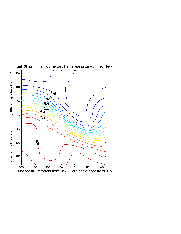
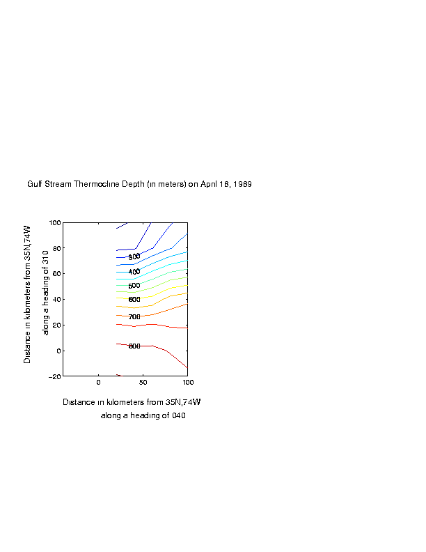
Contoured Maps of Thermocline Depth. A strong subsurface
temperature gradient, called the thermocline, is associated with the
Gulf Stream. The thermocline slopes downward from the sea surface to
depths of about 1000 meters on the southern side of the Gulf Stream.
Measurements of the subsurface temperature field were made by two
arrays of inverted echo sounders. One array (the Inlet Array) was
located near Cape Hatteras and the other (the Central Array) was
centered near 68W. The depth of the 12 degree Centigrade temperature is
contoured above using a 50 meter contour interval. The shallowest
depths (the upper right corner) are less than 150 meters and the
deepest depths (lowere right) are in excess of 850 meters. Click here
to bring up larger drawings of the contoured thermocline fields for the Central or Inlet Arrays.
-
Current Velocities. Currents at 400 meters depth were
measured at 11 sites and are shown by the black lines. The location of
each measurement is indicated by a plus symbol. The length of the
vector and its orientation indicate the current speed and its
direction. This measurements were collected as part of the SYNOP experiment.
-
RAFOS Float Tracks. The paths taken by 6 RAFOS floats are
shown by the blue lines. Each line segment indicates the location of
the float over a 32-hour period, centered April 19th at 1200 UT. Longer
tracks indicate that the floats were located in the swifter part of the
flow. Although the depth of the neutrally-buoyant floats changed along
the path, they were typically located at depths between 200 and 600
meters. The RAFOS float
data were supplied by Dr. Tom Rossby.
Dynamics of Ocean Currents Group at URI/GSO:
Maintained by Karen Tracey
Last Updated: September 18, 2000